पत्ती
Mirror Lake Scenic Byway
“Mirror, mirror on the wall—what is the most beautiful road trip of them all?”
Tessa Wren
लेखक
झलक
नीचे पूरा पाठ फ़्लोट करता है।
शेल्फ़
स्टोरी लीफ़
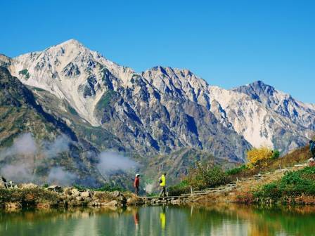
“Mirror, mirror on the wall—what is the most beautiful road trip of them all?”
Drivers exploring Utah don’t need magic to find an answer. Just under two hours from Salt Lake City lies the Mirror Lake Scenic Byway, a mountain route that feels almost storybook in its beauty. Winding through the Uinta Mountains, it passes jagged peaks, dense pine forests, rushing streams, and abundant wildlife—landscapes that feel almost unreal.
This section of State Route 150 climbs steadily from the town of Kamas up into high alpine terrain. The drive is smooth and scenic, rising from about 6,690 feet to Bald Mountain Pass at 10,715 feet—the highest paved road in Utah. The full 55-mile route reaches the Wyoming border and usually takes several hours to enjoy, though many travelers extend the journey with camping along the way under clear, star-filled skies.
The road is free to access and typically opens in late spring and closes in autumn once heavy snow makes travel impossible. Some recreation areas require permits, and conditions can change quickly at high elevation.
Kamas: Gateway to the Uintas
The journey begins in Kamas, often called the entrance to the Uinta Mountains. Local legend tells of early pioneers guided to a hidden gold deposit by Ute guides, on the condition the location would never be revealed—its whereabouts remain unknown to this day.
Before heading into the mountains, many travelers stop at Samak Smokehouse & Country Store for snacks and supplies. (“Samak” is simply “Kamas” spelled backward.) Smoked meats, cheeses, and trail food are popular choices. It’s also essential to refuel here—there are no gas stations beyond town.
Provo River Falls
Shortly after leaving Kamas, the route follows the Provo River, a renowned trout stream filled with brook, rainbow, and cutthroat species. One of the highlights is Upper Provo River Falls, where water cascades over layered rock into a narrow canyon.
Paths allow visitors to view different sections of the falls, and some even step into shallow areas in summer, though the water remains extremely cold year-round. Early morning is the best time for photography due to soft light and fewer shadows.
Alpine Lakes: Teapot, Lily & Lost
Higher along the byway, a series of serene mountain lakes appears beside the road. Teapot, Lily, and Lost Lakes are easily accessible, while others require short detours along forest roads.
These waters attract abundant wildlife. Moose often feed near the shoreline, while deer and elk are common throughout the region. Occasionally, black bears and mountain lions pass through. Birdlife includes osprey, bald eagles, and mountain bluebirds, making the area popular with nature watchers.
Bald Mountain Overlook
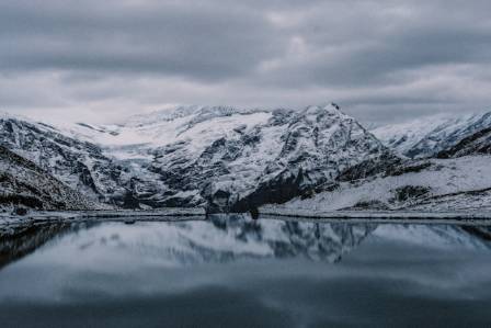
A side road leads to Bald Mountain Overlook, where visitors are rewarded with sweeping views of colorful rock formations made from ancient shale and quartzite. The Uinta Mountains are unusual in North America because they run east to west rather than north to south.
From here, hikers can also access a challenging route to Bald Mountain’s summit at nearly 12,000 feet, offering expansive alpine scenery for those willing to make the climb.
Mirror Lake: The Centerpiece
At over 10,000 feet in elevation, Mirror Lake is the highlight of the entire route. Its calm waters often reflect the surrounding peaks perfectly, especially early in the morning when the surface is still.
Fishing, kayaking, and paddleboarding are popular during summer, while a gentle loop trail allows visitors to walk around the shoreline. More challenging hiking routes nearby lead deeper into the Uinta wilderness.
Mirror Lake Campground, located nearby, is one of the most sought-after camping spots in the region. Nights here are quiet, and mornings often bring glowing reflections of the mountains in the still water.
Hayden Peak Overlook
Farther along the route, Hayden Peak rises sharply above the forested landscape. Named after geologist Ferdinand Hayden, the peak is especially striking at sunset when the rock glows with warm color. The area also connects to long-distance backcountry trails that cross the Uintas.
Christmas Meadows
A side road leads to Christmas Meadows, a remote area known for camping, hiking, and fishing. In early summer, the road can be rough, but later in the season, wildflowers fill the valley and streams offer excellent fishing opportunities.
Bear River Ranger Station & Final Stretch
Near the Wyoming border, the Bear River Ranger Station provides a quiet stop with picnic areas and a historic cabin from the region’s logging past. Beyond this point, the landscape opens into gentler terrain as the byway comes to an end.
From here, travelers can return the way they came or continue into Wyoming. Fall is especially beautiful, when aspens and maples turn brilliant shades of gold and red.
पास की पत्तियाँ
Zephyranthes rosea: The Rain-Blooming Lily Explained
Jordan Smith

क्या जानवर प्यार में पड़ते हैं?
तारा

Simple Street Wall Painting Ideas
Nora Whitman
The greatest station wagons ever
Luke Dean

7 प्रकार के पनीर जिन्हें आपको अपना अगला ग्रिल्ड चीज़ बनाते समय लेना चाहिए
जयदीप

पुरुषों की जैकेटों के लिए मास्टर गाइड: स्टाइल और कार्यक्षमता को निखारें
राजकुमारी सैन